After Helene, What Remains Of The Linville Gorge?
The Linville Gorge is one of the most spectacular and challenging wilderness areas in the eastern U.S. What did Hurricane Helene wash away?
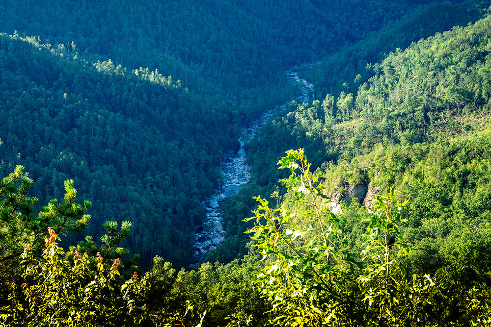
Near the end of an exhausting day on my first visit to Linville Gorge almost two decades ago, I walked up to a massive granite boulder that rested on the bedrock about 15 feet off the river. I stopped and stared. I tried to imagine what caused this rock, roughly the size of a Volkswagen Bus, to wind up in this spot. How? When?
Earthquakes aren’t common in North Carolina, so I guessed that this rock had fallen from the cliff above after a decades-long cycle of water seeping into tiny cracks, freezing, and expanding until the breaking point. What thunderous sounds must have echoed through the gorge when it fell? Had it frightened the black bears? Spooked the fish?
I wondered if it would ever move again. I tried to imagine the incredible natural forces that would need to conspire to budge this enormous rock from its resting spot. Already that day, I had seen immense trees atop boulders in the gorge, high above the normal water level. The power of Linville smacks you in the face with every step.
The Linville Gorge Wilderness Area, sometimes referred to as “the Grand Canyon of the East,” is renowned nationwide as one of the wildest and most rugged places east of the Mississippi River. It is, putting it bluntly, dangerous. Every year, multiple hikers and climbers are rescued, often by helicopter. The first friend I ever deemed worthy of a gorge adventure told me when we got back to the car: “Today was the greatest outdoor adventure of my life, but you can never tell my wife how dangerous it was because we have two kids, and she’ll kill me.”
Every time I’ve hiked this route through the gorge—down Cabin Trail, then following the Linville River, the only original trail through the rocky terrain—I’ve stopped to eat next to my rock and gazed in wonder just like the first time. Standing near the river, simmering in the relentless summer sun, my rock looks like a heart. From an angle closer to the cliff, a face straight out of Picasso’s Cubist period—with misplaced eyes, nose, and mouth—is unmistakable. My rock has layers. My rock felt eternal.
And then Hurricane Helene happened. From my home in suburban St. Louis, I watched video footage of water shooting from Linville Falls with incomprehensible force. This wasn’t just a generational flood. It was a flood unlike any in recorded history, one that obliterated records set by the Flood of 1916, long the benchmark for devastation in Western North Carolina.
If Helene hadn’t moved my rock, nothing ever would. I had to know.

Ryan’s rock, Photo by Ryan Fagan
Even at its most hikeable, the Cabin Trail is brutal. Switchbacks be damned: This as-the-crow-flies straight trail drops roughly 1,000 feet in just three-quarters of a mile.
Cabin is not so much a hike as a scrambling exercise over steep terrain, with rocks that are deceptively unstable and tree limbs that cannot be trusted as handholds. The only thing tougher than descending Cabin is going back up Cabin, and the only thing tougher than going up Cabin is descending Cabin. But it takes me to my favorite loop in the gorge—my rock is roughly the midway point—so I’ve “hiked” it more than a dozen times.
I’ve learned to be selective with the people I bring on the loop. At the end of one day trip with a couple of co-workers, one of them told me, without a trace of a smile: “Ryan, I just didn’t want to die today.”
On my first trip into Linville after Hurricane Helene—my mid-June quest to see if my rock had moved—Cabin was especially difficult. I kept thinking about a conversation I’d had a few weeks earlier with Lisa Jennings, the recreation and trails manager for the U.S. Forest Service’s Grandfather Ranger District.
“The trails that you’ll go on now are not the trails that you went on last summer, because the landscape has been changed forever,” she said. “Come extra-prepared, because things are still constantly changing. When we get big rains, landslides will move more dirt. Trees will continue to fall down because they’ve been weakened.”
Post-Helene, Cabin was an obstacle course.
Like most of the gorge’s trails, Cabin was open thanks to the tireless work of Jennings, her fellow Forest Service employees, and dozens of dedicated local volunteers who made hundreds of miles of trails passable. But passable, I quickly learned, is not a synonym for “clear.”

The parking entrance near the head of the Cabin Trail. Photo by Leslie Restivo
The Forest Service and local volunteers had cut and removed trees that blocked the path. But trees that allowed for a creative way around remained, and the trail was interrupted by upended root wads. At one point, with a tree across the trail, only a narrow tunnel was open through the foliage. I had to point my fishing rod into the foot-wide opening and wedge my way through.
I love, love, love the seclusion and peace of fishing in the gorge. But even I questioned the rationality of bringing the rod down Cabin that day. Three times, I had to take off my backpack and lower the rod so I could shimmy under, between, or over trees that crossed the trail.
At a particularly steep section, I had to trust my full body weight on a well-tested root to slip under a fallen tree. A tumble there would have been bad.
I had intended to tally the number of trees cleared off the trail, but I quickly lost count. I had to watch every step so carefully that at least two or three times, I stopped to catch my breath only to look up and realize that I’d passed a cleared tree. The entire way down, I repeated my Linville mantra, the same thing I’ve told everyone I’ve taken with me: “Be confident with your steps, but don’t be cocky.”

Writer Ryan Fagan had hiked the gorge multiple times over nearly 20 years—but not since Hurricane Helene sent floodwaters raging through its channel in September 2024. Photo by Leslie Restivo
The trail system inside Linville Gorge, a federally designated wilderness area, is minimalistic and designed for self-reliance. People are meant to visit, not stay. No blazes mark the path, and only a handful of signs direct you beyond the parking lots. Cell service is spotty at best on the ridges and virtually nonexistent down by the river.
“Gorge miles,” as locals call them, are exponentially more difficult than “regular” trail miles. Clearing the trails was important, but, in the days and weeks after Helene, they were an afterthought. People mattered more.
More than 30 inches of rain fell in some parts of Western North Carolina. The normal discharge rate for the Linville River at the U.S. Geological Survey monitoring station just south of the gorge is less than 100 cubic feet per second. On Sept. 27, at the height of Helene, it peaked at 28,300.
Jennings first needed to understand the scope of the damage. There was no point in clearing trees from the first mile of a trail if a significant landslide had wiped out the trail in the next mile. Jennings set—and met—a goal of assessing all 300-plus miles of trails in the Grandfather district by the end of 2024. Her team of Forest Service employees and experienced volunteers from local organizations, including Wild South and Southern Appalachian Wilderness Stewards, marked trouble spots on their phones and helped build an interactive Google map to determine a trail priority list.
“Internally, we were getting kind of delirious after working all these really long days, so we were calling it the ‘spicy scale,’ like for hot wings,” Jennings says. “How many chili peppers is this trail? The ones that are just destroyed, that’s a five-chili pepper, and the ones that just have some trees down, that’s a one-chili pepper.”
Federal regulations prohibit the use of motorized tools like chainsaws in designated wilderness areas. The entire gorge would have to be cleared with traditional tools like crosscut saws. “This situation was the ultimate test,’” says Kevin Massey, the executive director of Wild South, a Spruce Pine-based conservation group. “There was no playbook for this sort of disaster in a wilderness area.”

The U.S. Forest Service, with help from local organizations and volunteers, used traditional tools like crosscut saws—regulations prohibited motorized tools like chainsaws—to make the trail navigable through downed trees and branches. Photo by Ryan Fagan
In addition to local volunteers, Jennings was able to secure federal funding to bring in crosscut saw experts from U.S. Forest Service locations as far away as Oregon and Puerto Rico.
Slowly, trails started to reopen. By mid-May, most were passable save for a couple of long stretches of the Linville Gorge Trail that landslides had devastated. Those sections might not reopen until 2026 or later.
“The Linville Gorge recovery is a success story, period,” Massey says. “We have a seriously engaged community.”
I smiled when I reached the river. I always do. Emerging from Cabin with healthy ankles always feels like an accomplishment.
I dropped my pack and stepped into the chilly water. My sore feet thanked me. I took a moment to reset. I had no idea what to expect, aside from knowing I would find my rock even if Helene had moved it. A rock that big would be impossible to hide.
But, selfishly, I wanted it to be in the same spot. It’s been my touchstone— literally—since that first trip into the gorge.
I had seen the power of the Linville River in flood. In 2011, I walked across the Spence Ridge bridge, a couple of miles downstream from my rock. It felt like a marvel of engineering. I had visited the same spot after back-to-back floods in 2013 had pried the bridge from its moorings, uprooting concrete and rebar as if they were matchsticks. The side of my rock directly in the path of the floodwaters is wide and flat, providing plenty of surface area for the water to push against, especially if a couple of trees had stacked up in front. That was the bridge’s downfall.
The first river crossing on the loop is the shallowest I’ve found in the gorge—knee-high during a normal flow—but the smooth rocks have incredibly slick moss. Of course they do. I was eager to find my rock, but I don’t hurry in Linville. The gorge is meant to be experienced and enjoyed.
I made my way through the next section, a moonscape long ago scoured by floodwaters. The rocks and boulders ranged from the size of baseballs to billy goats. Finding stable rocks was a challenge. I made my way down the shore, stopping to catch a few feisty smallmouth bass and take pictures of the eastern newts hanging out in the larger puddles on the riverbank.
I’ve been down into Linville so many times that all my regular spots have memories attached. Some happened on solo trips like this one. Most happened with friends and relatives. I don’t just have “my rock” but my waterfall, my view, my camping spot, my bear track, and my favorite fishing spot.
In 2018, I brought my brother Seth and cousins Kevin and Charlie. It was an epic trip we still tell stories about, like the time Kevin fell—after a full day of heeding my advice and stepping carefully, he trusted a sturdy-looking rock that betrayed him—and busted his pinkie. When X-rays at a local hospital revealed it was just dislocated, not broken, we laughed for hours. I laughed all over again as I stopped at the spot to take a video that I sent the trio when I got back into cell service. “Thank you for this,” Charlie replied.
An hour and a half after I reached the river, I rounded a bend and looked downstream. There, nestled in the same spot under the cliff—half in the sun and half in the shade—was my rock. I ate lunch and rested in its shade. I stuck my head under the ice-cold water that dripped from the cliff above. I looked at the fallen trees on the opposite bank, where those the flood had knocked sideways crisscrossed others toppled over mini-landslides and pointed down the slope.
I turned back to my rock. As I always do, I wondered how it wound up there. This time, though, I felt confident that it won’t be moving anytime soon, if ever.